Walks
High-level thrills lead to the top of Pillar
Some Lakeland mountains draw you to them. They evoke a distant history and attendant mystery and whisper ‘climb me’: Helvellyn, Blencathra, Skidda...
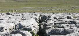
A short trip to Moughton's alien landscape
Distance: 12km (7½ miles) Ascent: 340m (1,115ft) Time: allow 3½ hours Map: Ordnance Survey Explorer, OL2, Yorkshire Dales southern and western areas or Harvey’s Superwalker Yorkshire Dales Three Peaks Note: grough routes should be used in conjunction with maps, a compass and other navigational aids.
Sea to Sea: we follow Wainwright from Coast to Coast
Britain has 15 national trails – long-distance paths and bridleways that offer a challenge to anyone who wants to walk, cycle or ride a horse over linked rights of way.
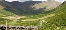
Harter Fell - the quiet way
Harter Fell from LongsleddaleNote: groughRoutes should be used in conjunction with maps, a compass and other navigational aids.
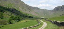
Great Gable, the way the climbers see it
Great Gable, Green Gable and Base Brown from SeathwaiteNote: groughRoutes should be used in conjunction with maps, a compass and other navigational aids.
Solitude beckons on the Howgills' velvet slopes
Quite unlike their near cousins the Yorkshire Dales and the Cumbrian Fells, the velvety bumps of the Howgill Fells have a character all of their own.
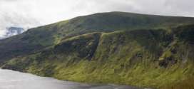
Border post: White Coomb and the Grey Mare's Tail
Mention hillwalking and Scotland in the same sentence and most people automatically think of the Highlands: munros, romantic-sounding Gaelic names, precipitous edges.
Calderdale's moorland green lungs
Distance: 16.6km (10⅓ miles)Ascent: 340m (1,115ft)Time: allow 5 hoursMap: Ordnance Survey Explorer, OL21, South PenninesNote: grough routes should be used in conjunction with maps, a compass and other navigational aids.
The West Highland Way: 95 miles of pain, pleasure, plasters and pasties
The walker setting forth on the West Highland Way is embarking on a trip through history. Not only will his or her route pass through scenes of bloody...
Ingleborough's little corrie
Map: Ordnance Survey Explorer OL2, Yorkshire Dales southern and western areas or Harvey’s Superwalker Three PeaksNote: groughRoutes should be used in conjunction with maps, a compass and other navigational aids.
Pages
Most recent
Commented
2 On test: Montane Anti-Freeze XT Hoodie reviewed
3 Campaigning Kate Ashbrook celebrates 40 years as head of Open Spaces Society
4 Kinder Scout walker calls out rescuers after sinking up to thighs in mud
5 Ultrarunner Jasmin Paris posts first finish by a woman in gruelling Barkley Marathons
6 On test: Danner Cascade Crest boots reviewed
7 More than 40 involved in rescue of injured walker who spent 24 hours on Scafell Pike
8 On test: winter waterproof jackets reviewed
9 Lakeland paraglider dies after crashing on Blencathra
2 BMC proposes 12-month trial of permitted wild camping in England and Wales (8)
3 Blencathra walker rescued after falling more than 60ft from Sharp Edge (7)
4 Explorer Scout Ben Leonard was unlawfully killed in Great Orme fall, jury finds (7)
5 Bodies of three hillwalkers recovered from Aonach Eagach ridge in Glen Coe (5)
6 Dartmoor national park bosses will fight bid to overturn camping verdict (4)
7 Llanberis rescue team volunteers 'close to limit' as callouts top 300 in 2023 (3)
8 Campaigning Kate Ashbrook celebrates 40 years as head of Open Spaces Society (3)
9 Summer's over; it's getting darker and colder. Time to wise up to winter on the hill (2)