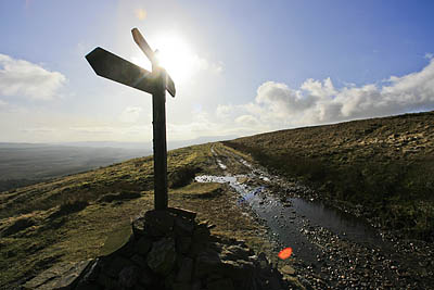
 Outdoor groups fear rights of way that have existed for centuries could be lost forever if a legal deadline for recording them is not put back.
Routes on Definitive Maps, such as this one are safe, but thousands are at risk
This follows the announcement in March that the Government’s Discovering Lost Ways project was being abandoned. The scheme was meant to map footpaths and bridleways that had not been officially recorded.
The Countryside and Rights of Way Act, which granted limited rights to roam in England and Wales, stipulated that any historic rights of way not included on official maps by January 2026 would be lost forever. But the Discovering Lost Ways (DLW) project has been a dismal failure. It is estimated there are 20,000 such paths, a half of which are visible on the ground, but have never been recorded.
Natural England, the Government body given the task of running DLW, admitted that the original scheme was too expensive and time consuming.
It was originally envisaged that the recording of the lost routes could be done by volunteers, but it quickly became evident this was not going to work and an Archive Research Unit was set up, using a private company. Cheshire, Shropshire, Nottinghamshire and Wiltshire were chosen to run a pilot scheme; the results were underwhelming. The unit came up with an average of just 0.7 potential cases in each parish it studied.
The likely cost of finding the lost routes across would exceed £11m and by the time they had made their way on to the Definitive Maps – often involving a public inquiry – this would soar to £80m. The Archive Research Unit is now out of the picture.
The problem was aired in a House of Lords debate tabled by British Mountaineering Council member Lord Greaves, a Liberal Democrat peer.
Lord Greaves told the House: “Some £4.5 million spent in two counties – Cheshire and Shropshire – have resulted in a grand total of no additions to the definitive map. Therefore, it has been a complete flop.
“It was based on library research, and local volunteers were not really involved. It was a case of looking at ancient maps and documents, inclosure awards, tithe maps and even the land surveys which Lloyd George instituted for his land tax in 1910.”
He pointed out that Natural England’s report on the failure of the DLW project recommended the setting up of a stakeholder group to look at how to tackle the problem.
This would include representatives of highway authorities, landowners and user groups.
But Lord Rooker, a minister in the Department for Environment, Food and Rural Affairs, warned that the issue would not go away.
He told the House: “I understand that the three parties that will come together in the stakeholder group are very happy with the process and the way forward.
“There is a degree of consensus that, if the present system does not work, we will find another way to do it.
“But the clock is ticking on the 25-year limit, as was implied in the remarks of the noble Lord, Lord Greaves. It is now less than 20 years away and, as the legislation stands, the cut-off date is 1 January 2026.
“That can be extended by regulations, but only for the five-year limit up to 1 January 2031.”
The Government had agreed not to implement the parts of the CRoW Act which set the limit until the stakeholder groups had deliberated. But the Open Spaces Society, which campaigns to protect rights of way, and of which Lord Greaves is also a member, is worried about this.
It said: “It is not sufficient for ministers to say they will not pursue its implementation. A hostile Government could implement it while it remains on the statute book.
“It is vital that we get the cut-off date repealed.”
The OSS also said it was concerned that the Government is proposing a fundamental review of the legislation and process relating to access provisions.
The society said the cut-off was only included in the CRoW Act as a sop to landowners for access to their land.
Natural England points out that many of the ‘lost routes’, which date from before 1949, are in use daily – they were just missed off the original Definitive Maps.
Clearly, the research-led method of cataloguing these rights of way has been a massive and costly failure. The pressure is now on the stakeholder group to come up with a solution before the limit wipes them out, legally, forever.
As Lord Rooker said in reply to Lord Greaves: “This is a sad state of affairs, in a way, as it has not worked out as intended.
“We recognise the importance and value of the rights of way network. The health and quality-of-life benefits of walking, cycling and horse riding are well known.
“There is a degree of uncertainty, but we still have a long way to go.”
There are there are 151,000km (94,000 miles) of footpaths, 32,000km (20,000 miles) of bridleways in existence in England.
Guest
13 July 2008Why should you have to prove that a right of way exists by looking at old documents? Give people the legal right to access the country they live in, whoever owns it. England & Wales need more civilised access law, like Scotland.