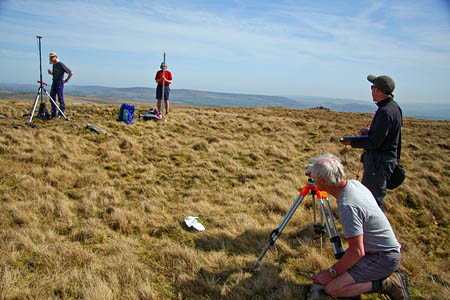
A team of hillwalking enthusiasts has added a Yorkshire Dales fell to a hill list after deciding it measures up to the mark.
The team of five spent almost eight hours surveying the hill near Malham with a view to adding it to the register of deweys.
The list consists of hills in England, Wales or the Isle of Man, that are more than 500m high and below 610m, with a drop of at least 30m on all sides. The deweys, named after original compiler Michael Dewey, are in effect the smaller cousins to the hewitts, which have a similar prominence, but are at least 2,000ft (610m).
The elevation of Kirkby Fell, west of Malham, to the list, came after the trio of hill sleuths John Barnard, Graham Jackson and Myrddyn Phillips, used highly accurate Global Positioning System equipment to record both the summit height and the height of the col between it and neighbouring Rye Loaf Hill.
The trio were accompanied by Brent Lynam and Mark Trengove who used conventional surveying equipment to confirm the readings. Kirkby Fell had been suggested as a candidate for the dewey list independently by John Kirk of Blackburn and David Purchase of Bristol who both told the surveyors the hill had a good chance of making the list.
Mr Phillips told grough: “Over the last few years we have reclassified so many hills that are now not in the list so we were quite excited to be able to add a hill to the dewey list.”
He said it was the first new dewey in about 10 years. The men set off last Sunday from Malham and first measured the col. “It’s quite complicated; a wall crosses the col and took a bit of working out. We surveyed it optically and put out a line of flags,” Mr Phillips said.
“We then used the Leica 530 [GPS equipment] and got about an hour’s worth of data. We wanted to find out while we were on the hill whether it would make the list, so we line-surveyed up to the top of the hill.
“It’s slightly more accurate than the GPS readings – within about 2cm compared to the 3 to 4cm we can achieve with the Leica.”
The surveyors confirmed there was a rise of 30m, as suggested by the Ordnance Survey contour lines, between the col and the summit. The actual prominence was measured at 31.1m.
The next task was to accurately measure the height of the hill, the second requirement for dewey listing.
Myrddyn Phillips continued: “We found the summit position on the edge of a sink hole, about 10m away from the cairn and then measured to the summit. We gathered another hour’s data with the Leica and then prepared a line survey.
In the end, it had a height of 546.4m – the OS map shows 546m so they’re very accurate on this one.”
Kirkby Fell, named after the village of Kirkby Malham, will now be entered on the list of deweys maintained by John Barnard. Michael Dewey, who first compiled the list which appeared as one of the chapters in his book Mountain Tables, maintains overall control of the list of 433 hills.
The summit of Kirkby Fell is at grid reference SD 873 635.
