Walks

Follow in the Brontë sisters' footsteps to Top Withins, inspiration for Wuthering Heights
Take to the romantic wild Brontë moors, home to Cathy and Heathcliff, on this walk starting in the hilltop village of Haworth in West Yorkshire .
Bidean nam Bian and Stob Coire Sgreamhach from Glencoe
From: Allt-na-Ruigh (Allt-na-Reigh), Glencoe Peaks: Stob Coire nan Lochan; Bidean nam Bian; Stob Coire Sgreamhach Munro tally: two, plus one munro top Distance: 11km (6.8 miles) Ascent: 1,250m (4,100ft) Navigation: fairly easy in good visibility, challenging in mist Strenuousness: a real test of legs and lungs with stiff, sustained ascents of big hills Trickiness: some scrambling, at the easy end of the scale; very little exposure Time: allow about 7 hours Glencoe rightly tops the list of many outdoors aficionados, with its towering mountains enclosing a spectacular 16km (10-mile) road stretching from King's House in the East where the glen starts to drop down from Rannoch Moor, to Glencoe village in the West, with Loch Leven opening out a watery vista.
Cross Fell and Great Dun Fell
From Kirkland, Cumbria Distance: 19.2km (12 miles) Ascent: 890m (2,920ft) Navigation: mostly easy, but some sections confusing in mist Strenuousness: a long walk with plenty of ascent, though most is at a steady gradient Trickiness: nothing technical, no scrambling Time: allow about 7 hours The Cross Fell massif is a place of superlatives.
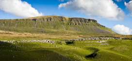
Pen-y-ghent from Horton in Ribblesdale, via Plover Hill
From Horton in Ribblesdale via Hull Pot, Plover Hill Distance: 9.5km (6 miles) Ascent: 510m (1,673ft) Navigation: careful navigation needed in poor visibility Strenuousness: fairly hard, gentle at first, but tough ascent to Plover Hill and final sting in the tail to Pen-y-ghent summit.
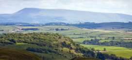
Ingleborough: the complete walking guide
Ingleborough, one of Yorkshire’s Three Peaks, cuts a distinctive shape when viewed from the North and West, its table-top plateau ending abruptly in a series of steep escarpments.
Ingleborough from Ingleton
From Ingleton (Storrs Common) Distance: 4.5km (2¾ miles) Ascent: 540m (1,772ft) Navigation: easy Strenuousness: gentle ascent until final, steeper 500m Trickiness: straightforward, apart from a couple of easy steps across limestone near Greenwood Pot Limited parking is available in laybys at the side of the main B6255 Ribblehead road at Storrs, including a few in a small disused quarry beyond the last house on the left.

Ingleborough from Newby Cote
From Newby Cote Distance: 4.7km (3 miles) Ascent: 500m (1,640ft) Navigation: tricky in parts; good navigation skills required Strenuousness: mostly gentle ascent but some tussock yomping required Trickiness: no technical problems, mainly moorland The hamlet of Newby Cote, on the old road between Clapham and Ingleborough, has very limited parking at the junction of the lane to Newby.
Ingleborough from Horton in Ribblesdale
From Horton in Ribblesdale Distance: 7.5km (4⅔ miles) Ascent: 490m (1,608ft) Navigation: easy navigation, a little confusing on lowest limestone paths in bad visibility Strenuousness: gentle ascent until last 400m Trickiness: no technical problems; limestone can be slippery through Sulber Nick when wet The route up Ingleborough starts from the railway station.
Sheffield Pike: pocket peak with grand views
For a man who spent half his life walking the fells, Alfred Wainwright comes across in his writings as an unconfident navigator.
Pen-y-ghent from Foxup
From Foxup, returning via Pen-y-ghent Gill Distance: 16.5km (10¼ miles) Ascent: 510m (1,673ft) Navigation: moderate; some navigation skills required in poor visibility Strenuousness: moderate, reasonable fitness and stamina required on longish route with sustained ascent Trickiness: some easy scrambling over rocky sections, nothing too exposed Time: allow five to six hours for full circular trip Marilyn tally: one; Hewitt tally: two; Nuttall tally: two The walk up the least lofty of the Yorkshire Three Peaks starts from the remote hamlet of Foxup, the end of the metalled road up Littondale, named after its main village rather than the river, the Skirfare, which flows down it.
Pendle Hill from Barley
From Barley, Lancashire Distance: 8km (5 miles) Ascent: 340m (1,115ft) Navigation: easy, but care needed on summit plateau if visibility poor Strenuousness: a short walk with a stiff slog up the path up to the summit Trickiness: nothing technical, no scrambling Time: allow about 3 hours Pendle Hill misses out on the Ordnance Survey benchmark for mountains by 173ft (53m) but makes up for it by its tautological name, packed history and fantastic views.
Pen-y-ghent from Horton in Ribblesdale via the Pennine Way
From Horton in Ribblesdale via Pennine Way Distance: 5.3km (3¼ miles) Ascent: 450m (1,476ft) Navigation: easy, good tracks and footpaths all the way Strenuousness: a long, gentle slog Trickiness: nothing technical, no scrambling Time: allow 2¾ hours (ascent only) Pay-and-display parking is available in Horton's national park car park with good toilets near the bridge by the Crown Inn (still marked on OS maps as the New Inn), but there are also places to park either on the streets or the large layby at the southern end of the village.
Bleaklow from Longdendale
Distance: 17.2km (10⅔ miles) Ascent: 475m (1,558ft) Navigation: good navigation skills required – summit plateau can be very confusing.
Ingleborough from Austwick
From Austwick Distance: 8.6km (5⅔ miles) Ascent: 590m (1,936ft) Navigation: good navigation skills required, especially in poor visibility – some off-path walking Strenuousness: steep ascents on to Norber and final section of path on to Ingleborough summit Trickiness: no exposure, but rocky sections The route starts in the village of Austwick, a haven of peace just a stone’s throw from the busy A65.
Ingleborough from Chapel-le-Dale
Distance: 3.9km 2½ miles Ascent: 420m Navigation: fairly easy Strenuousness: a fair slog Trickiness: care needed above Humphrey Bottom on steep section There is car parking on the roadside layby on the B6255 Low Sleights Road, a couple of hundred metres north-east of the Old Hill Inn.
Ingleborough from Clapham
From Clapham Distance: 7.1km (4½ miles) Ascent: 580m (1,903ft) Navigation: easy navigation if Clapdale nature trail used; some easy route-finding needed on alternatives Strenuousness: gentle ascent until final kilometre Trickiness: no technical problems, just don’t fall down Gaping Gill Parking is available in the pay-and-display car park in Clapham, where there are also toilets.
Whernside: Yorkshire's highest point, with a hint of Cumbria
England’s biggest county can claim a few records, but when it comes to the heights of its hills, Yorkshire’s record books can be a little confusing.
Bag Crianlarich's twin peaks in one day
This walk is a chance to bag two munros in one outing. The giant twin peaks of Crianlarich, Ben More and Stob Binnein, are a great destination which, ...
Pages
Most recent
Commented
2 Police appeal for sightings of walker Ruth Betts, missing in Mamores
3 Summer holidays' start prompts Lakeland rescuers' plea to reduce 'avoidable' callouts
4 Injured Helvellyn walker among eight callouts for busy Patterdale rescuers
5 Runner Joss Naylor 'King of the Fells' dies aged 88
6 Lake District avalanche survivor reunited with rescuers, 40 years on
7 On test: Camelbak Octane 22 Hydration Hiking Pack reviewed
8 Runner Jasmin Paris among outdoors personalities recognised in birthday honours
9 Mountain rescue finance chief Penny Brockman appointed OBE
2 Blencathra walker rescued after falling more than 60ft from Sharp Edge (7)
3 Campaigning Kate Ashbrook celebrates 40 years as head of Open Spaces Society (3)
4 Llanberis rescue team volunteers 'close to limit' as callouts top 300 in 2023 (3)
5 More than 40 involved in rescue of injured walker who spent 24 hours on Scafell Pike (2)
6 Kinder Scout walker calls out rescuers after sinking up to thighs in mud (1)
7 Lakes boss Richard Leafe will quit at end of year for new career as Mountain Leader (1)
8 Runner Joss Naylor 'King of the Fells' dies aged 88 (1)
9 Lakeland paraglider dies after crashing on Blencathra (1)