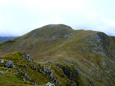
Pity poor Sgurr nan Ceannaichean, whose munro status was short lived. Photo Nick Bramhall
Guest contributor Dave Hewitt staked a pint on Tuesday that his prediction on the ups and downs of the munro-corbett lists would prove correct.
Dave forwent the joys of the Indian summer to make the journey to Milton of Campsie, in East Dumbartonshire, where hillwalking statisticians were holding their breath as two amateur hill sleuths held court to make their announcement: just how high were the four mountains in question?
We reckon Mr Hewitt’s predictions warrant a half of heavy, with perhaps a whisky chaser. Here’s why.
On grough earlier this week I offered my predictions for the imminent munro-list alteration, suggesting that: (a) three of the four resurveyed hills would stay the same in category terms; (b) the one change would be a demotion, munro to corbett; and (c) the demoted munro would be Ben Vane, on the west side of Loch Lomond.
The results were announced on Thursday afternoon, at a Munro Society press conference held in the pleasant surrounds of Kincaid House Hotel in Milton of Campsie, and (a) and (b) proved to be correct. There was indeed only one change, but no promotion: Sgurr a’Choire-bheithe ended the day as it started it, a corbett with a height of 913m. The precise reading – a little too precise for some people’s liking – was 913.43m. The highest ground is bang on where the spot height appears on the map, and 68cm higher than the base of the cairn, some distance away. (All these figures, according to surveyors John Barnard and Graham Jackson, are reliable to plus-or-minus one centimetre for horizontal location and three centimetres for altitude.)
So there was to be no 285th munro – but which of the existing 284 would be chopped down to corbett status? The answer proved to be Sgurr nan Ceannaichean, most northerly of the surveyed hills and the least likely of the three existing munros to change according to my pre-match analysis. Why did I think this? Because when I was there in November last year, it was obvious that the small cairned point at the top of the southern slope was higher than the main cairn. Hence, so my thinking ran, the hill’s height was likely to go up a little rather than down, making it safe as a munro.

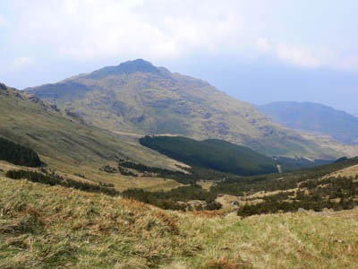
Ben Vane. Predictions of its downgrading were wide of the mark. Photo: Nick Bramhall
Flawed thinking, as it transpired. The small cairn is indeed the summit, comfortably so: the surveyors reckon it’s 91cm above the base of the big cairn. Trouble is, the big cairn is only at 912m, and the whole hill comes in at 913.43m, short of the necessary 914.4m (3,000ft) height. So back down into the ranks of the corbetts it goes, where it will undoubtedly have a quieter life given that munroists outnumber corbetteers by something like 20 to one.
As for the other two, Beinn Teallach didn’t see much action at all, being surveyed as 914.60m, just 20cm above the 3,000ft mark. And my punt of Ben Vane actually increased by a metre, with the summit, an outcrop near to the westernmost cairn, being measured at 915.76m.
As mentioned in my earlier grough piece, I did go and climb Ben Vane the day before the announcement, in an adieu sort of way, and my mate Mike and I had a pleasant time even if we didn’t make one of the final ascents of it as a munro. We went up the steep southern side and down the standard baggers’ path, the first time I had been on that for a few years, my normal way off being towards the Sloy dam. The path is badly eroded, almost dangerously so in a couple of places high up, and the hill would have benefited from conversion to corbett status in those terms at least. The highlight was a curious encounter: a man, aged 60ish, without a rucksack, wearing a flat cap, and carrying one of those green recyclable shopping bags that supermarkets are big on these days. We stopped for a chat after he asked how far it was to the top, and he was very polite.
Anyway, back to the resurvey announcements. The press conference was well attended, both by journalists (it was good to see the bald, oops, bold Mr McNeish; his own blog-prediction had been ‘according to very reliable sources, there will be several changes to the status of some hills’), and by an impressive panel up front.
The two surveyors were present of course, as were Derek Sime and the venerable Iain Robertson from the Munro Society. Then there was Rab Anderson, convenor of the Scottish Mountaineering Club publications committee, Graham Little of the Ordnance Survey (also an SMC member, although he wasn’t wearing that particular hat), and Jim Melville of CMCR surveyors, the firm used by the Munro Society for their 2007 visits to Foinaven and Beinn Dearg. He was serving as a professional advisor this time round.
Anderson was asked how quickly the Sgurr nan Ceannaichean change would come into operation, and he simply shrugged and said ‘as of now’, although it will of course take some time for new editions of maps and guidebooks to pick up on it.

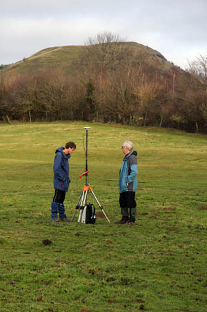
Graham Jackson and John Barnard at work on a previous survey, operating the differential GPS at the col of Earl’s Hill on the Wales-England border
There was also discussion of accuracy and verification, as these new heights are given to such a level of precision-confidence as to engender mild scepticism. No one is suggesting that Barnard and Jackson are anything other than competent and diligent surveyors, and the OS has given their work the all-clear, so these new heights stand without quibble. But my understanding of standard experimental rigour is that readings should ideally be verified by a second survey if at all possible. Then, if the two readings are near enough the same, confidence jumps markedly, not least because it effectively rules out any possibility of simple data-entry error.
When Barnard and Jackson went to assess the distinctly un-munro-like high-point of Wiltshire (along with their colleague Myrddyn Phillips, who attended the press conference sporting a striking combination of plaited ponytail, green Welsh kilt and glamorous blonde assistant), they did take their readings twice. A first visit provided one set of figures, after which a return trip, with an OS surveyor and a Countryfile TV crew in attendance, provided another – and the two sets of numbers, while not identical, were close enough to nail down the result.
Such rigour is unlikely with these munro surveys, due to the expense and the equipment-lugging awkwardness involved, but the Beinn Teallach result – just 20cm above munro level – felt close enough such that a second reading would help to bolster confidence. Graham Jackson, however, felt there was no need for that: “A second survey would return results within 10cm of the first one,” he said.
The surveyors were also sure that windy weather is not a problem, as the length of time – two hours plus – during which on-site GPS data is gathered is such that any rogue readings would be ironed out of the system. The Beinn Teallach and Ben Vane surveys, however, were done on consecutive mid-May days that were remarkably windy for such activity: 50mph gusting to 75mph for Beinn Teallach, 45mph gusting to 60mph for Ben Vane. It is a bold claim to say that Beinn Teallach is definitely between 10cm and 30cm above the munro threshold based on readings taken in such a hefty gale. In this one instance at least, surely a return visit, made in calm conditions and perhaps by some rival surveyors, would help to boost data-confidence and dismiss any lingering doubt.
Overall, however, this batch of surveys has been a triumph for the people involved, especially for the Munro Society. Even without either of the two biggest results (a change to Ben Vane or Sgurr a’Choire-bheithe would undoubtedly have been a ‘better story’ than a change to Sgurr nan Ceannaichean or Beinn Teallach), they’ve still managed to nudge their way into a variety of newsrooms. The profile and reputation of the Munro Society, and of Barnard and Jackson, is definitely on the rise (plus or minus a few centimetres).
So what will happen next? Barnard and Jackson will return to looking at lower-profile summits south of the border, but in time they’ll be back to team up again with the Munro Society. There is certainly no shortage of quirkily topped hills out there to merit future study. Might they survey Knight’s Peak, controversial outlier of Sgurr nan Gillean in the Skye Cuillin? It’s a technically tricky summit to reach, and not everyone is convinced by the height of 914.95m obtained in 2006, courtesy of a more traditional OS-plus-SMC surveying combo, a measurement which saw Knight’s Peak attain munro-top status. Word is that various of the Skye guides still regard it as below 3,000ft, and a re-resurvey making it something like 914.2m would be entertaining, as that would place the SMC and the OS on one side of the fence and the Barnard/Jackson/Munro Society grouping on the other, rather than the polite togetherness witnessed of late.
Fraser
12 September 2009The whole thing is kind of daft if you ask me...