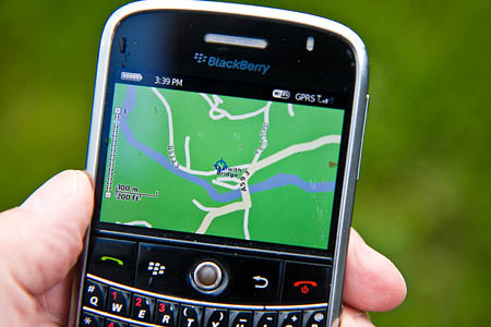
The built-in basic mapping that comes with many smartphones is not up to the job of mountain navigation
Mountain rescuers have warned of the danger of relying solely on mobile phones to navigate while on the Lakeland fells.
Langdale and Ambleside Mountain Rescue Team said it is dealing with an increasing number of callouts to walkers who have got lost because they are using a mobile phone to navigate.
Many smartphones now have built-in Global Positioning System receivers and can get a fix from the GPS satellites, but the rudimentary mapping that comes with them as standard is not suitable for hillwalking navigation.
Away from roads and main features, the fells are likely to be represented as just empty green space, giving no idea of steep gradients and other hazards, and rights of way.
Ordnance Survey mapping can be bought and uploaded to some phones, turning them essentially into handheld GPS devices.
A spokesperson for the team said: “These devices may well work if the right mapping is installed, and the instructions have been fully understood, but otherwise risk being worse than useless.
“They also drain batteries significantly faster than when using the phone only.
“Car sat-navs are equally useless. The less preparation you make, the more likely you are to spend a cold, miserable, wet night out on the fells!”
Another problem is that large tracts of the Lake District have no mobile phone signal or very poor coverage. Even basic online mapping may not load if a phone signal cannot be obtained.
Navigation advice is always to carry paper maps as a back-up even if electronic mapping is available, in case batteries or hardware fail. Most batteries also perform more poorly when cold.