 Harter Fell from Longsleddale
Note: groughRoutes should be used in conjunction with maps, a compass and other navigational aids. Routes often use access land and involve finding your route off footpaths. Knowledge of and competence in using a map and compass is essential when using the routes. Carry the correct equipment for the conditions and be aware of hazards in the outdoor and mountain environment.
Longsleddale: starting point for the route
Escaping the crowds in the English Lake District is never easy, but this route, on the far eastern side of the national park, steers clear of the honey pots while delivering some stunning scenery. So keep it quiet: it's our little secret.
The route starts at Sadgill in Longsleddale, a beautiful valley which starts with typical valley scenery before plunging into crag-dominated terrain typical of the Lake District. Take the A6 Shap road out of Kendal. Four miles out, take the left hand turn, signposted Longsleddale, and begin the torturous drive along the single-track road to Sadgill. Caution is the word for the drive, and you'll struggle to exceed 20mph on most of the route, so take it easy and be alert for any vehicle coming the other way.
The hamlet of Sadgill is two farmsteads and a bridge. Interstingly, a Google search performed before your journey will inform you http://www.estateangels.co.uk/trades_kitchen_fitters/sadgill that there are no kitchen fitters in Sadgill. Try and get over this, for there is at least space for half a dozen cars at the terminus of the metalled road. Please take note of the signs – there are many of them – and don't block access to any of the various bits of the hamlet the farmers may need access to.
The online source of everything Wikipedia also notes, though how credible this is, grough will leave to you to decide, that the valley you're in was the inspiration for Greendale, home of Postman Pat. See if you can spot Pete Fogg and Mrs Goggins on during your excursion.
Greendale inspiration or not, there's not doubting Longsleddale is a tremendous valley, with the sylvan solidtude of its southern reaches giving way to the cragginess of its upper section, with the delightfully named River Sprint in turns tumbling or meandering along its bottom.
Our grough route takes us up the walled track towards the Gatescarth Pass, formerly a Byway Open to All Traffic, which is now subject to a traffic regulation order. In a nutshell, drivers and riders of 4×4s and motorcycles have to apply for permits to use the green lane, and it will only be open to them for one day a month. If you object to the sight and sound of the infernal combustion engine, here are this year's days to avoid (2006): 2 July, 4 August, 2 September, 6 October, 5 November and 1 December.
Continue northwards up the track. The crags of Goat Scar jut impressively into the valley as the route starts to steepen. grough visited Longsleddale on a sunny June Saturday and the only other people using this section were a (presumably illegal) trail bike rider and a family enjoying the waterfalls to the left.
Leave the track by a climbers' still over the right-hand wall at NY 478 075. Seasonal restrictions apply to climbing on Buckbarrow Crag, due to nesting ravens, so if you're tempted to get out your ropes and karabiners, check that you're not disturbing the raven chicks.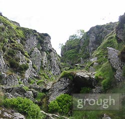
Take a route to the left of the crag immediately ahead of you, up the steep grass slope. There are climbers' paths in the area, but these lead, naturally, to the foot of the climbing routes and are not for us. There now follows a brief gill scramble up the deep gully leading diagonally to the right (see picture, right). When grough visited, the gill was mostly dry, but if there's too much water or you don't fancy the scramble, take the route to the left of the heather-clad butress, following the line of the thin scree and rejoin our route by heading right over the top of the butress.
Make for the fence corner at 484 078. The OS map is missing a fence that runs SE from this corner and shows the one leading E to W even though the fence is no longer there, its rusting posts being the only sign of its previous existence. Head for the high ground of Tarn Crag, keeping to the left of the rocky outcrops and on to the summit plateau, to gain sight of the sizeable stone pillar.
The pillar, (see picture below) at 487 077 has a cleft at the top and is in line with two others, one to the north near Artle Crag and the other to the south on Great Howe. These were used during surveying for the construction in the 1930s of the Haweswater Aqueduct designed to take 12m gallons of lakeland water the 74 miles from  Haweswater via Kendal, Kirkby Lonsdale, Accrington, Haslingden and Bury to Manchester's Heaton Park.
A short distance east from the pillar at 488 078 is a small cairn marking the highest point of Tarn Crag. On a good day, there are extensive views east to Shap and the Pennine fells beyond, while Kentmere Pike, Harter Fell, and Kidsty Pike fill the vista to the West and North-West. Windermere glistens to the South-East. If you're not so lucky and the cloud is down, there are extensive views of grass for 10m in each direction.
From the pillar, a faint path leads north and crosses the fence at 487 082. The route then follows the fence downhill into the secluded valley of Mosedale which has a very remote feel to it. The head of the track from Londsleddale is visible to the left, as it passes the disused mines and quarries of Wrengill.
Our grough route continues straight ahead, continuing alongside the fence as it starts the slog up Selside Brow. Follow the wall to the summit plateau of Branstree, a broad expanse of grass. Cross the stile in the fence and walk 30m forward to an unusual small concrete circle, adorned on the day of grough's visit by two sea shells. The weather-worn inscription reads 'Ordnance Survey Trigonometrical Station' – a small cousin to the familiar concrete triangulation pillars usually found on summits.
Mardale and Haweswater are still hidden by the broad expanse of Branstree's grassy top, but a diversion 300m north-east to the cairn opens up a view above Artle Crag.
Return to the OS circle, then back to the fence, which our route now follows down to the col at Gatescarth Pass, with fine views to the impressive crags of Harter Fell. Cross the track and start the climb to the summit of Little Harter Fell before gaining the summit of its slightly higher big brother. The footpath misses the left-hand peak of Adam Seat, but those intent on bagging another peak, particularly anyone with a devilish streak, can follow the fence to the 666-metre high mound.
Harter Fell was originally listed as a Marilyn in The Relative Hills of Britain, though it was later found not to have the required 150 m of relative height, and thus misses out by one metre. Console yourself by noting that you have, in fact, already conquered the route's only Marilyn, Tarn Crag.
The rise up to the summit affords great views of Haweswater, High Street, Kidsty Pike and High Raise.  Two sizable cairns (see picture right) contain more scrap metal than Harold Steptoe's yard and make a bizarre spectacle. Tear your eyes away from the mangled remains of the fenceposts and you can feast them instead on the distant views of the central fells: Scafell, Scafell Pike, Great Gable and their lesser neighbours.
The summit cairn, marking the 778m top of the fell, is scarred by fewer twisted fence posts and sits on a wide, grassy plain. Sit and enjoy the views before starting the return leg of the route, which follows the fence south with good views of the western neighbours Thornthwaite Crag, Froswick, Ill Bell and Yoke, which tower above Kentmere. The walk to Kentmere Pike follows a broad, grassy plateau. The summit trig point of the pike in on the eastern side of the wall; use the throughstones to visit it then return to the western side and follow the wall and fence until 469 071 where it leads right, towards Shipman Knotts rather than following the fence line towards Goat Crag. Take care not to follow the fainter, right-hand path which will drop you down into the Kentmere valley at Hallow Bank.
Cross the wall at 471 067 and head south to rejoin the wall. Our route continues to lose height and crosses a few rocky steps down to meet the High Lane track, a route linking the Kentmere valley with Longsleddale. Turn right on to the track, following it to the gate on the left, on the other side of which is the public byway sign. Go through the gate and follow the track to Low Sadgill , ,over the bridge to the starting point.
Robert Trewhitt
04 January 2008Totally agree about this area and the route. Alternative route just as good is round the end of Haweswater to Mardale Head (excellent views), up Kidsty pike (excellent views and you might even see an Eagle), left onto High Street and the Roman Road, left (after visiting Thornthwaite Pillar) past Small Water (excellent views), straight onto the Nan Bield pass and Harter Fell. Left off Harter Fell down the lovely zig zag path (excellent view) to Mardale (Haweswater). As a footnote: if you wanted to stay in the area The Haweswater Hotel is excellent. Peace and quiet guaranteed, excellent food, no tele, no phones, no mobile signal HEAVEN. A true outdoor persons paradise.