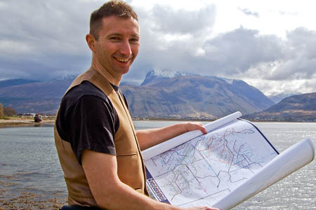
An ex-geography teacher has produced a unique new map of Scotland’s 3,000ft mountains.
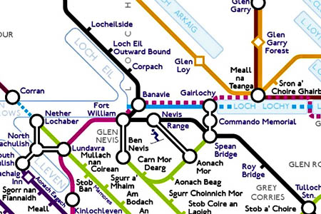
Peter Burgess’s innovative MunrOverground is a representation of the nation’s 283 munros, depicted in the style of the London Underground map.
The creation is a follow-up to the London-based outdoor enthusiast’s Tubular Fells, which mapped the Lake District’s fells in a similar fashion.
And the East Ham hillwalker has pledged to donate part of the proceeds from sales to conservation charity the John Muir Trust and to Scottish mountain rescue’s umbrella body.
Mr Burgess’s new map, again in the style of Harry Beck, creator of the familiar London Tube diagram, groups the mountains into a number of lines, including the Skye Line, the Knoydart, Skye and Affric Line and the Southern Hills.
These are blended with the national rail network, and long distance paths such as the West Highland Way, Sutherland Trail and Great Glen Way also feature.
Mr Burgess said: “After Tubular Fells I had my eyes set on the Himalayas or the Rocky Mountains for my next design, but people quickly started asking, ‘are you going to produce one for the Scottish munros?’
“I knew even before starting to plan it that the MunrOverground would look much more like a national rail network than one belonging in one city. Like Tubular Fells, it’s certainly a little out of the ordinary, but I hope it shows the relationships within the Scottish landscape in an enlightening and eccentric way.
“I’ve thoroughly enjoyed mapping Scotland. It’s a place with a great heritage and landscape to boot.
“Looking at a large Ordnance Survey map of Scotland could be quite overwhelming, but with all the detail stripped away to reveal the basic information, you can see each landmark and their relationship with one another more clearly.
“It includes all 283 munros, but there are so many other features worthy of mention that I couldn’t resist including.
“One of my favourite areas is around the Ratagan Pass, near the village of Glenelg so it received particular attention, with the last ferry to Skye, a valley with some fantastic brochs, and Sandaig, the isolated spot where Gavin Maxwell lived when he wrote Ring of Bright Water.
“I’ve not climbed many munros, but a tally approaching 40 isn’t too bad. I’ve climbed lots of the lesser hills, with Suilven being one of my favourites. In creating this map, I’ve not only learned a lot about Scotland and its fantastic mountains, but like the tube map itself, it begins to make sense. “
John Hutchison, chairman of the John Muir Trust, said: “The MunrOverground is hugely inspiring, I’m sure that anyone who loves Scotland’s wild places would be glad to hang it on their wall.
“We are really happy that Peter has decided to support the John Muir Trust through sales of the map. It seems fitting since the trust looks after many of the wild places featured, including Ben Nevis, Schiehallion, Quinag and Sandwood Bay.”
Shaun Roberts, project manager for the Mountain Rescue Committee of Scotland, said: “We are delighted to be associated with such a creative project and are very grateful for the offer of contributions.
“We have more than 1,000 team members volunteering to save lives throughout the Scottish mountains, any hour, any day, any weather. Contributions from sales will go towards supporting the many initiatives currently underway within the national organisation which represents and supports the 33 individual rescue teams.”
The MunrOverground map is available from Mr Burgess’s Tubular Fells website as an A1 poster, priced £12.99. £1.50 from each sale will be shared between the John Muir Trust and Scottish Mountain Rescue. The map’s creator is warning orders may take time to fulfil.


Sean Clark
27 April 2012Oh a London Underground map is it. Why cant they leave our hills and geography alone in all its disharmony and randomness. In urbanising our landscapes theyre effectivley recreating their metroplitan homeland. Ive never seen anything so ridiculous and insulting. Stop trying to tame us!
Craig W
27 April 2012Apt - Munros are for trainspotters, so why not a train-style map? ;)
I am guessing the sub-way map to Britain's official long distance paths will be next.
Think I will stick to the OS though, imagine mountain rescue finding you lost on the hill, asking if you have a map and you pull one of these beauties out.
Ian
29 April 2012Just calm down everyone!
It is an attempt to raise money for the John Muir Trust, not some fiendish urban plot to destroy the world!
Charles Britten
30 April 2012It will be 282 Munros when Ordnance Survey finally get round to de-listing Beinn a' Chleibh.
E Spoff-J
26 October 2012All my OS maps are now heading to the bin, all I need is this handy map and an oyster card! Great idea Peter, highland/underground fusion!