Ordnance Survey
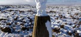
Happy birthday to the trig pillar, 80 years old today
A familiar friend to hillgoers is celebrating an 80th birthday today. Ordnance Survey’s first triangulation pillar went into use on 18 April 1936...
Ordnance Survey takes quarter stake in Dennis Maps, printer of paper maps
Britain’s official mapping agency has bought a 25 per cent stake in a company that prints its paper maps.
Britain from the Air photo exhibition lands in Leeds
A touring exhibition offering views of Britain from the Air lands in the UK’s third largest city this week.

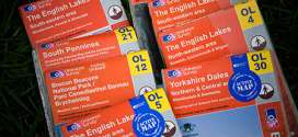
Ordnance Survey increases sales of paper maps after decade of decline
Sales of conventional paper maps produced by Britain’s official mapping agency increased last year, bucking the trend in the past decade which saw people opting for digital versions.
GPS pressure leads Ordnance Survey to ponder map co-ordinates change
Britain’s national mapping agency is considering abandoning a system of co-ordinates on its maps first devised more than 180 years ago.
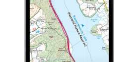
Ordnance Survey free smartphone app will help walkers in a fix
Britain’s national mapping agency has launched a free smartphone app to provide navigationally challenged walkers with their location.
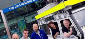
GO Outdoors challenges public to Walk Around the World in 80 Days
Britain’s biggest outdoor retailer is teaming up with industry bosses and mountain rescuers in challenging to the public to walk round the world.
Corbett survey by hill sleuths leads to separation of Highland twins
A survey by a pair of hill sleuths led to the separation of Highland twins. Two peaks above Glen Shiel that had previously been classified as a twi...
Ordnance Survey aerial camera unit moves to new base
Britain’s national mapping agency has set up its aerial photography unit at a new site. Ordnance Survey’s flying unit, which produces the photo...
Britain's highest mountain Ben Nevis gains a metre in height
The United Kingdom’s highest mountain just grew by a few inches. But a sudden tectonic upsurge hasn’t hit the Highlands of Scotland; rather, Be...
Ordnance Survey to offer digital downloads with its paper maps
Britain’s official mapping agency is to offer digital downloads with its paper maps. Although sales of Ordnance Survey paper maps rose for the fi...
Minister says there are no plans for Ordnance Survey privatisation
The coalition Government said it has no plans to privatise Britain’s national mapping agency. Ordnance Survey will shortly become a government-ow...
Minister announces plans to make Ordnance Survey a government-owned company
A minister has announced plans to turn Britain’s national mapping agency into a government-owned company.
Ordnance Survey denies report of end of paper maps for Great Britain
Britain’s national mapping agency said claims in a newspaper report that it was to end routine production of paper maps across the whole of Great Britain are untrue.
Eastern turn for compasses for first time in 200 years as North shifts
Walkers in the far South-West of England are experiencing a phenomenon not seen for more than 200 years.
Outdoor fans can now feature on their own OS map cover
Outdoor fans ordering a custom map from Britain’s official mapping agency can now feature on its cover.

Green award for mapping agency's new headquarters
The head office of Britain’s national mapping agency has been recognised as one of the most sustainable in the country.
Tweeting surveyors give insight into Ordnance Survey work
Surveyors from Britain’s national mapping agency are putting themselves on the map, with the help of microblogging network Twitter.
Pages
Most recent
Commented
2 Record-breaking runner Tom Hollins prepares for longest challenge: the Lakeland Round
3 Scrambler airlifted from Lakeland mountainside after tumbling 160ft
4 Rescuers pay tribute to David Parrish who died on Cape Wrath Trail challenge
5 Teens rescued after failing to find Priest's Hole during Storm Dave
6 Company behind Dragon's Back Race and Cape Wrath Ultra goes out of business
7 Two rescue teams and two helicopters go to aid man after 300ft fall on Helvellyn
8 Pre-pack administration deal allows Alpkit to continue trading
9 Ex-gamekeeper Racster Dingwall fined for raptor persecution in first case of kind
2 Rescuer injured as team battles Storm Amy 80mph winds to reach injured walker (5)
3 New West Yorkshire national nature reserve will include Brontë moorland (4)
4 Rescuers offer guidance after callouts to Lakeland wild campers (4)
5 Rebuild of Culra Bothy will be charity's most expensive project to date (3)
6 Happy 60th birthday to the Pennine Way (2)
7 Work on 'dreaded' stretch of Coast to Coast Walk paves way for National Trail opening (2)
8 The Angry Corrie founder Dave Hewitt dies, aged 64 (2)
9 Sébastien Raichon wins Montane Spine Race at first attempt (1)