Ordnance Survey

Trigs, tithes and topography: OS history goes online
The pace of mapping developments is hard to keep pace with these days, with every day seemingly offering a new electronic means of viewing maps, exporting routes to GPS units and downloading applications for the latest smart phones.
Free Ordnance Survey mapping may follow Government u-turn
Outdoor enthusiasts were handed an early Christmas present today with the announcement that the Government could make leisure mapping free to users.
OS mapping to be freed – but not for the outdoors
Prime Minister Gordon Brown today announced an opening up of public access to Ordnance Survey maps. Speaking at a Downing Street seminar, Mr Brown ou...
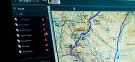
Find your way with our great new mapping and route system
Imagine having top-quality maps of the whole of Britain at your fingertips, so you can plan your outings from the Isles of Scilly to Shetland; from East Anglia to the Isle of Man.
Welsh peak will bear name of 'lost princess'
A Welsh peak will join a family circle this weekend, following a concerted campaign to have it renamed.
Creag joins marilyn list after hill sleuths' survey
Britain has a new marilyn after an announcement today by three amateur hill surveyors. Graham Jackson, Myrddyn Phillips and John Barnard’s effort...
grough launches cheapest digital Ordnance Survey mapping service
You may have had your fill of the January sales, but here’s a bargain we don’t think you can refuse.

OS map data: what happened to the consultation?
A public consultation on the future of Ordnance Survey mapping failed to materialise this week. Despite assurances from a Government minister that ...
Latest Ordnance Survey maps added to grough's route system
grough’s unique online route-planning system has now been updated with the latest Ordnance Survey mapping.
New mapping system will help colour-blind
Britain’s national mapping agency has introduced a new product to help people who are colour-blind read maps more easily.
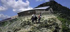
Surveyors have new mountain cafe mapped
Snowdon’s new summit cafe will appear on maps from September after Ordnance Survey staff mapped the building.
Pages
Most recent
Commented
2 Record-breaking runner Tom Hollins prepares for longest challenge: the Lakeland Round
3 Scrambler airlifted from Lakeland mountainside after tumbling 160ft
4 Rescuers pay tribute to David Parrish who died on Cape Wrath Trail challenge
5 Teens rescued after failing to find Priest's Hole during Storm Dave
6 Company behind Dragon's Back Race and Cape Wrath Ultra goes out of business
7 Two rescue teams and two helicopters go to aid man after 300ft fall on Helvellyn
8 Pre-pack administration deal allows Alpkit to continue trading
9 Ex-gamekeeper Racster Dingwall fined for raptor persecution in first case of kind
2 Rescuer injured as team battles Storm Amy 80mph winds to reach injured walker (5)
3 New West Yorkshire national nature reserve will include Brontë moorland (4)
4 Rescuers offer guidance after callouts to Lakeland wild campers (4)
5 Rebuild of Culra Bothy will be charity's most expensive project to date (3)
6 Happy 60th birthday to the Pennine Way (2)
7 Work on 'dreaded' stretch of Coast to Coast Walk paves way for National Trail opening (2)
8 The Angry Corrie founder Dave Hewitt dies, aged 64 (2)
9 Sébastien Raichon wins Montane Spine Race at first attempt (1)